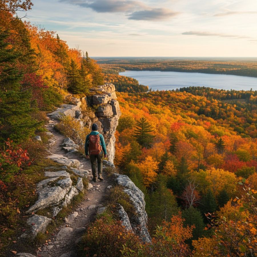
The first time you hike the Niagara Escarpment section of the Bruce Trail near Mono Cliffs, the landscape does not match what most people expect from Southern Ontario. The trail drops through cedar forest, crosses open meadows on the cliff edge, and opens onto views that stretch for kilometres across Dufferin County. It is a reminder that this part of the province has serious terrain, not just flat farmland and subdivisions. The trails listed here cover a range of difficulty, from easy afternoon loops to multi-day backcountry routes.
The Bruce Trail
The Bruce Trail runs 900 kilometres from Niagara to Tobermory along the Niagara Escarpment, making it the longest marked footpath in Canada. You do not need to through-hike the entire thing. Most people access short sections, typically 5 to 15 kilometres, from trailheads scattered along the route. The Bruce Trail Conservancy maintains the path and publishes detailed maps and a guidebook that is worth buying if you plan to hike more than once.
The best day-hike sections depend on what you want. The Forks of the Credit area near Cataract offers waterfalls and river crossings in a relatively easy loop. The Beaver Valley section near Kimberley has more elevation change and better views. The Tobermory section, particularly the stretch near the Grotto in Bruce Peninsula National Park, is the most famous and the most crowded. In July and August, Parks Canada requires timed entry reservations for the Grotto, and they sell out weeks in advance.
Mono Cliffs Provincial Park
Mono Cliffs sits in the Dufferin Highlands, about 90 kilometres northwest of Toronto. The park has several loop trails ranging from 3 to 8 kilometres, all manageable in half a day. The Cliff Top Side Trail follows the escarpment edge and connects to the main Bruce Trail. The terrain is rocky in places, with wooden boardwalks crossing wetter sections. Spring wildflowers here are excellent, but the trails turn muddy well into May. Fall colour, typically peaking in mid-October, is the park's strongest season.
Awenda Provincial Park
Awenda is on the Georgian Bay shoreline near Penetanguishene, about 150 kilometres north of Toronto. The park has roughly 30 kilometres of trail covering forest, wetland, and shoreline. The Bluff Trail is the standout: a moderate loop through hardwood forest that opens onto views of Georgian Bay. The beach trail leads to a quiet sand beach that is swimmable in July and August but cold the rest of the year. Awenda is less busy than provincial parks closer to Toronto, which is a significant advantage on summer weekends. For more trail options and outdoor planning resources in the province, Adventures for Wilderness covers routes across Ontario.
Ganaraska Forest
The Ganaraska Forest is a 4,500-hectare tract of managed forest east of Toronto, near Port Hope. The trail network is extensive, well-maintained, and hilly. This is not flat lakeside walking. The terrain rolls through pine plantations and mixed hardwood stands, with enough elevation to make a 10-kilometre loop feel like a workout. The forest is also popular with mountain bikers, so be aware of shared trail etiquette. A day-use permit is required. The Ganaraska is one of the better options for a hiking day trip from the eastern GTA without driving all the way to the escarpment.
Dundas Peak
Dundas Peak, part of the Spencer Gorge Conservation Area near Hamilton, became one of Ontario's most photographed hikes after social media discovered it. The trail is short, roughly 3 kilometres round trip, and the view from the peak over the Dundas Valley is legitimately impressive. The problem is volume. On fall weekends, the parking lot fills before 10 a.m., and the Hamilton Conservation Authority has implemented a reservation system to manage the crowds. If you go, book your time slot in advance and arrive early. If you want a similar escarpment view with fewer people, try the Chedoke Radial Trail on the Hamilton mountain instead.
Algonquin Park Highland Backpacking Trail
The Highland Backpacking Trail in Algonquin Park is a step up in difficulty from everything else on this list. The Western Uplands trail system offers loops of 32, 55, and 71 kilometres through rugged Canadian Shield terrain. These are multi-day routes requiring backcountry camping permits, bear canisters or hang systems, and proper gear. The reward is solitude and scenery that the car-camping areas of Algonquin cannot match. The eastern Highland Trail, at 35 kilometres, is a popular two-night option with excellent lookout points. The east gate of Algonquin is roughly 310 kilometres from Toronto, about a 3.5-hour drive via Highway 60.
Forks of the Credit Provincial Park
Forks of the Credit is a small but rewarding park in the Caledon Hills, about 75 kilometres northwest of Toronto. The main loop is roughly 5 kilometres and follows the Credit River past a waterfall and through mixed forest on the escarpment. The trail connects to the Bruce Trail for longer options. The park is close enough to the GTA to be a popular day trip, which means weekend parking is tight. Weekday mornings in autumn are the sweet spot. For more route ideas and cycling and trail connections, Ontario Bike Paths is a useful planning resource.
Trail Etiquette and Seasonal Notes
Mud season runs from early April through mid-May across most of Southern Ontario. Trails on the escarpment and in low-lying forests become waterlogged and fragile. Hiking through mud widens trails and causes erosion. If a trail is a swamp, turn around. Many conservation areas close trails seasonally for this reason.
Blacklegged ticks carrying Lyme disease are now established across most of Southern Ontario, including areas where they were rare a decade ago. Long pants, tick checks after every hike, and awareness of tick habitat (tall grass, leaf litter, forest edges) are no longer optional precautions. The Public Health Agency of Canada publishes updated risk maps annually.
On shared trails, hikers yield to horses and horses yield to bikes, though in practice most encounters come down to common courtesy and a bit of communication. Pack out everything. Leave the trail cleaner than you found it. Many of these parks run on thin budgets and minimal staff, and the condition of the trail depends largely on the people who use it. For additional fall hiking and driving routes across the region, our seasonal guide covers the timing by area.